Adam Hartley | New Delhi
At least 288 people have been killed and nearly 200 are still missing following massive landslides in Kerala, southern India, described by officials as one of the worst natural disasters in the region’s history.
The landslides in the Wayanad district, known for its rugged natural beauty that attracts millions of tourists annually, uprooted trees, knocked down communication lines, submerged roads, and washed away a bridge. The villages of Mundakkai and Chooramala, under the Vellarimala village of the Meppadi Panchayat, were swept away in landslides that occurred at 2 a.m. and 4:10 a.m on July 30, respectively.
Rescue operations resumed Thursday as the construction of a Bailey bridge connected landslide-hit areas where several people are believed to be stranded. The Indian Army, National Disaster Response Force (NDRF), and local emergency response departments continued their extensive search and rescue operations to find those feared trapped in the tragedy.
Congress MP from Kerala, Shashi Tharoor, has urged the federal government to declare the Wayanad landslides a “calamity of severe nature” to facilitate urgent assistance. Tharoor noted that on July 30, a series of devastating landslides struck Wayanad, claiming over a hundred lives and leaving many injured in hospitals, while countless others remain missing beneath the debris.
“We are focusing on the hope of rescuing some people still because the truth is 200 lives have been lost, but another 200 people are missing,” Tharoor said. “Two villages have disappeared from the map in this severe crisis… I have asked for it to be declared a severe calamity because, under the MPLADS fund, any MP in India can donate up to Rs 1 crore for a natural calamity once the government declares so.”
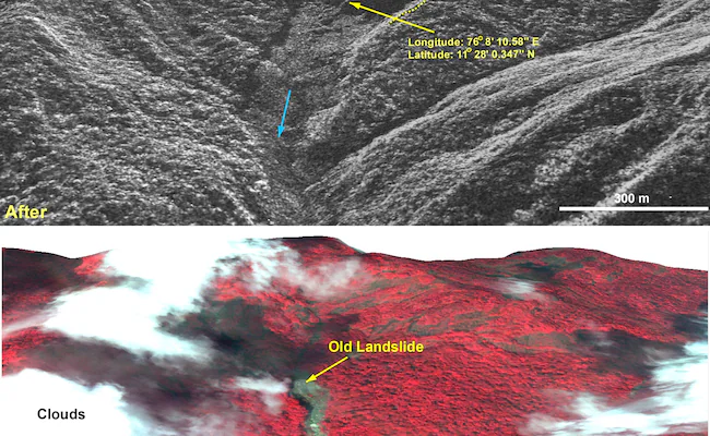
The Indian Space Research Organisation (ISRO) released satellite images showing the extensive damage in the region. Triggered by heavy rainfall, the landslide originated at an altitude of 1,550 meters. According to the NRSC report, the landslide was exacerbated by a major debris flow initiated by torrential rains in and around Chooralmala town, covering an area of 86,000 square meters.
The satellite images depict the before and aftermath of the landslide, where the debris flow widened the river’s course, resulting in significant damage to houses and infrastructure along the banks.
ENDS


